 Bryce Canyon National Park
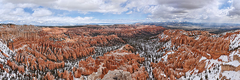
Image copyright Jean-Christophe BENOIST
Bryce Canyon National Park (pronounced /ˈbraɪs/) is a national park located in southwestern Utah in the United States. The major feature of the park is Bryce Canyon which, despite its name, is not a canyon but a giant natural amphitheater created by erosion along the eastern side of the Paunsaugunt Plateau. Bryce is distinctive due to geological structures called hoodoos, formed by wind, water, and ice erosion of the river and lake bed sedimentary rocks. The red, orange, and white colors of the rocks provide spectacular views for park visitors. Bryce sits at a much higher elevation than nearby Zion National Park. The rim at Bryce varies from 8,000 to 9,000 feet (2,400 to 2,700 m).
The Bryce area was settled by Mormon pioneers in the 1850s and was named after Ebenezer Bryce, who homesteaded in the area in 1874.[1] The area around Bryce Canyon became a U.S. National Monument in 1923 and was designated as a national park in 1928. The park covers 56Â square miles (145Â km2) and receives relatively few visitors compared to Zion National Park and the Grand Canyon, largely due to its remote location. The town of Kanab, Utah, is situated at a central point between these three parks.
This information uses material and images from the Wikipedia article “Bryce Canyon National Park”, which is released under the Creative Commons Attribution-Share-Alike License 3.0 and the images are licensed under the Creative Commons Attribution 3.0 Unported license.